Lines on the Map: How Protected Sightlines Quietly Decide Where Britain's Towers May Rise
Long before a planning committee convenes, before the render has been commissioned or the wind study commissioned, the fate of many a British tower has already been sealed — by a line drawn on a map decades ago.
These are the protected sightlines: viewing corridors, height limits and strategic vistas that thread through our cities like tripwires. To the casual observer, the skyline appears to be the product of market forces and architectural ambition. In reality, it is often the product of geometry — and of the people who guard it.
The Original View Stealer
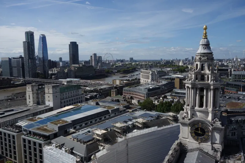
London's St Paul's Heights, introduced in stages from the 1930s, were arguably the world's first systematic skyline policy. Their purpose was simple: ensure that Wren's dome would remain visible from key points across the capital, and that no developer's greed would crowd out the cathedral's silhouette.
The results are unmistakable. Stand on Primrose Hill and the dome still commands the skyline, flanked by towers that step respectfully away from it. The Shard, for all its 310 metres, was carefully sited and sculpted in part because of these very constraints — Renzo Piano's tapering form owing as much to sightline analysis as to aesthetics.
But the policy has consequences. Vast tracts of the City and Southwark sit within zones where height is capped or heavily conditioned, pushing tall buildings into a narrow band east of the Tower — the cluster that has become London's de facto supertall district.
Beyond the Capital
This is not merely a London fixation. Birmingham's planning framework protects views toward the Council House and St Philip's Cathedral. Edinburgh's World Heritage Site status effectively freezes tall development across much of the city centre. Manchester, freer in some respects, still negotiates carefully around the Town Hall's Victorian profile and the views from Salford Quays.
In each case, the question is the same: what is a view worth, and who gets to say?
The Guardians and the Challengers
The machinery of view protection employs an unlikely cast. Heritage officers within local authorities spend their days conducting photomontage assessments — wireframe tower models dropped into verified photographs from fixed viewing points, testing whether a proposed tower would breach a corridor.
Then there are the amenity societies. Bodies such as the Victorian Society and the Twentieth Century Society, alongside local civic trusts, have become sophisticated operators in the sightline game, lodging objections not on the grounds of a building's design but on its intrusion into a protected vista.
Developers, for their part, have learned to play the same game in reverse. Some now design their towers around the corridors — tapering a crown, shifting a lift core, shaving four storeys off a top — precisely so they can claim compliance. Others commission their own heritage consultants to argue that a corridor, drafted in the 1970s, no longer reflects how the city is actually experienced.
Stewardship or Straitjacket?
The debate splits cleanly into two camps.
To defenders, sightline protection is the purest form of urban stewardship. A city's great landmarks belong to everyone, and a view from a public footpath is, in a sense, a public asset — one that, once surrendered, cannot be recovered. The St Paul's Heights have outlived every fad and fashion in planning precisely because they encode a value that markets cannot price.
To critics, the arithmetic is less romantic. Britain faces a chronic housing shortfall, and view corridors frequently sterilise the very plots — well-connected, centrally located — best suited to dense residential development. A corridor that protects a glimpse of a dome from a moving car, they argue, is a luxury paid for in homes not built.
There is a middle position, and increasingly it is the one planners occupy. Recent revisions to London's planning guidance have refined the corridors, distinguishing between views of genuine civic significance and those that merely fossilise an accident of history. Some axes have been relaxed; others hardened.
The Floor-by-Floor Reality
For those of us who track towers storey by storey, sightlines are the hidden variable in nearly every height calculation. The reason a scheme in Southwark tops out at 28 floors while its near neighbour reaches 60 is rarely geology or demand. It is a line on a map.
And those lines are being redrawn, slowly, one examination-in-public at a time. Watch the local plans, not the cranes, if you want to know where Britain's next generation of towers will rise.
The view stealers, it turns out, were never the developers. They were the draftsmen who got there first.